How to Protect Vadodara from Floods: A Solid Plan for Permanent Flood Prevention and Strategic Water Diversion from Ajwa Dam
On July 31, 2019, the city of Vadodara experienced a deluge with 18 inches of rainfall, causing widespread flooding. Despite this, the authorities learned nothing from the devastation caused by the floods five years ago. On August 26, 2024, the city faced another flood as 12 inches of rain fell, plunging Vadodara into water once again.
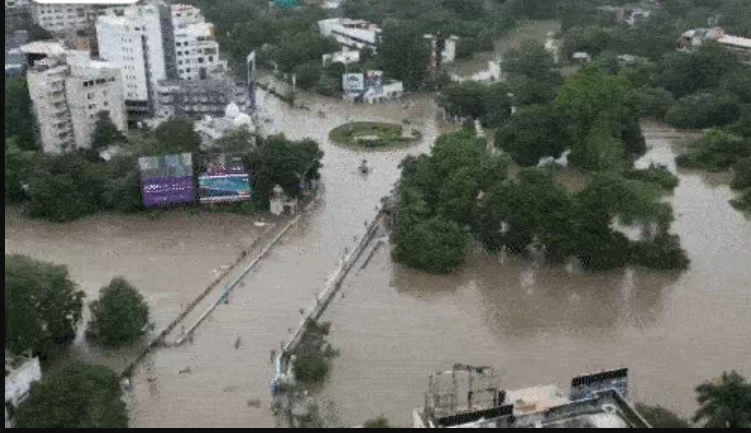
For the past two days, residents have been living amidst water. Currently, Vadodara is completely submerged, and it will remain uncertain until Thursday evening whether the waters have receded.
Let’s explore why this major city of Central Gujarat, known for its cultural heritage and historical rule by the Gaekwad family, now administered by the municipal corporation, is once again grappling with the threat of floods.
Additionally, let’s understand through motion graphics what plans the state government has to protect Vadodara from such floods in the future.

Why Did the Flood Happen?
On August 25, due to the activation of three weather systems in Gujarat, heavy rainfall began in Vadodara, with additional rain falling in the upstream areas such as Godhra and Panchmahal. The city is bisected by the Vishwamitri River, with the urban area located on both sides of the river.
There are more than ten bridges connecting these banks within Vadodara. The Vishwamitri River is linked to the Ajwa Dam, and it starts in the northeastern part of Vadodara before joining the Vishwamitri River.

On August 26, Vadodara experienced 12 inches of torrential rain, leading to a rise in the Ajwa Dam’s water level, which began to overflow. The excess water from the dam flowed into the Vishwamitri River. As the river’s water level rose with the influx from the Ajwa Dam, it began to overflow into the city of Vadodara.
When and How Did the Water Levels Rise?
Vadodara and its surroundings have over ten small and large lakes, with three major ones being well-known: Harni Lake, Sama Lake, and Sursagar Lake. Sursagar Lake is situated in the city center, while Harni and Sama Lakes are located in the northeastern part of the city, very close to the Vishwamitri River.
Due to the heavy rainfall, these lakes began to overflow. Simultaneously, the rain upstream caused water from the Ajwa Dam to flow into the Vishwamitri River. As the lakes overflowed, their water started flowing into the city, while the Vishwamitri River’s water level continued to rise. This rise in the river’s level surpassed dangerous thresholds, contributing to the flooding in Vadodara.
August 26: Vishwamitri River Level Surpasses 30 Feet
The situation in Vadodara city began to deteriorate from the morning of August 26. Rainfall continued in the city, causing lakes to overflow and the Ajwa Dam to release water continuously due to upstream rainfall. This resulted in water seeping into the city. On August 26, the Vishwamitri River’s water level exceeded 30 feet, putting Vadodara at risk of severe flooding.
Evacuations began in the low-lying areas of the city, with 2,500 people displaced that day. The intense flooding caused widespread panic among residents. Although the heavy rain stopped in the evening and there was no rainfall the following day, the continuous release of water from the Ajwa Dam further worsened the situation in Vadodara.
August 27: Vishwamitri River Reaches Dangerous Levels, Water Enters Homes
By the morning of August 27, the Vishwamitri River’s water level had risen to 33.50 feet, causing water to infiltrate homes ranging from modest huts to multi-crore bungalows. In societies like Siddharth Bungalows, the water reached up to the upper floors, forcing residents to flee in a desperate attempt to save their belongings, vehicles, and lives. Many found themselves unable to exit their homes due to the severity of the flooding.
People were pleading with authorities for assistance, demanding food and water supplies. However, no aid had arrived, and residents were left struggling for every drop of water. While some areas received a response from the authorities, many regions remained inaccessible.
By the night of August 27, the Vishwamitri River’s level had reached 37 feet. The state government decided to close the gates of the Ajwa Dam to halt further inflow into the Vishwamitri River, hoping to reduce the level from 37 feet back to a normal range of 31 feet.
On the morning of August 28, water levels began to slightly recede in some areas, and the rain stopped. State government spokespersons, Ministers Rishikesh Patel and Jagdish Vishwakarma, visited Vadodara and stated that while the current situation was a result of natural factors, efforts would be made to prevent a recurrence.
Government’s Plan
According to Minister Rishikesh Patel, the gates of the Ajwa Dam will need to remain open. To manage the Vishwamitri River’s water, it is proposed that the river be connected to the Narmada Main Canal. This connection would allow for the diversion of Vishwamitri’s water into the Narmada Main Canal when necessary.
The Narmada Main Canal starts from the Sardar Sarovar Dam near Kevadia and runs northward, passing close to Vadodara and extending toward Rajasthan. This plan aims to manage the water flow more effectively and reduce the risk of flooding in Vadodara by utilizing the existing infrastructure of the Narmada Main Canal.
5,000 People Relocated and 1,200 Rescued
Minister Rishikesh Patel reported that so far, 5,000 people have been relocated and 1,200 have been rescued. Currently, one NDRF (National Disaster Response Force) team, one SDRF (State Disaster Response Force) team, and one army column are operational. Additionally, one more NDRF team, one more SDRF team, and three army columns have been added to the effort.
These teams are working to address priority issues in severely affected areas, including the distribution of food packets, water, and medical emergencies. The authorities are fully prepared to handle these complaints and provide necessary assistance.
Gates of Ajwa Dam Closed Temporarily
Minister Rishikesh Patel stated that MPs and MLAs have been actively assisting without concern for their own safety. New teams are being deployed in heavily affected areas such as Harni, Sama, Akota, Ajitnagar, Siddharth Fatehganj, and Vadodara. These teams are addressing issues related to water, food, and medical emergencies, and additional boats have been arranged. Fire teams are also being integrated into the distribution efforts.
Due to the risk, the gates of the Ajwa Dam have been temporarily closed. The Vishwamitri River is currently at 37 feet. If it exceeds 30 feet, the water begins to spread into Vadodara. The situation is critical, but the focus of the administration and government remains on Vadodara. Efforts are underway to assist trapped individuals, provide rapid treatment, and address the needs of young children.
Hope for Reduction in Vishwamitri River Level
The spokesperson minister added that 38,000 food packets have already been distributed, and an additional 100,000 food packets are being prepared for distribution soon. The Vishwamitri River’s level has been rising, but both dams have been closed to prevent further inflow.
There is currently no water in the Pratappura and Ajwa catchments, which gives hope that the Vishwamitri River level will start to decrease.
The government’s efforts are focused on normalizing the situation within the next 15 hours. If rainfall continues, arrangements will be made to provide food, water, and medical services to those in relief camps.
Arrangements for Water Diversion to Khambhat Basin
The spokesperson mentioned that this situation has arisen for the second time in 20 years since 2004-05. Given that the Vishwamitri River flows through the area and with overflow from two reservoirs and other water bodies, discussions have been held with the municipal commissioner.
It has been proposed to divert excess water from the Ajwa Dam through an additional channel into the Narmada Main Canal, which could then be routed to the Khambhat Basin. This arrangement is aimed at managing and reducing the impact of the current flooding.


